Cornton, Corntoun or Corntown has its roots in Mediaeval history, although there is evidence that the Romans passed through about AD 145. Ella McLean’s book “Bridge of Allan: the rise of a village” speaks of a Roman coin, a sestertius, found close to the river at Cornton in 1962.
(The word sestertius means “two and one half”. It refers to the nominal value of two and a half asses, a value useful in commerce because it was one quarter of a denarius, a coin worth ten asses.)
As the name suggests, the area was almost wholly Agricultural, thriving on the rich alluvial soils of the Haugh. The jurisdiction of the area, historically, is almost exclusively linked to the Northern side of the river, there being little or no crossing save for a ferry, ford or early wooden bridges linking it to the South and Stirling. Consequently the area has always been contained within the Parish of Logie.
This from “Scotland’s oldest Bridges” website: –
Bellenden’s 16th century translation of Boece tells us that Agricola “come to Striuelyng…. and nocht lang efter he byggit ane bryg ouir Forth…”. However, Boece provides no source and is not renowned for reliability. The definitive source should be the Roman historian Tacitus, but he records nothing of this kind. Tacitus does note, however, that when the army moved beyond the Scottish isthmus, it was “…as if into another island” (The Agricola, 23 (Ref)). Certainly, the geographical and military significance of this particular river crossing continued throughout medieval times and on until the eighteenth century. Movement between northern and southern Scotland was vitally influenced by the topography of the Forth Valley. The Stirling crossing has always been the great junction of Scottish traffic.
These writings refer to the movement of the Roman Army North circa 140 – 208 AD.
After the Romans had left, during the fifth century Scotland was made up of four separate kingdoms namely the Picts, the Scots of Dal Riata in the West, the Britons of Strathclyde and the Kingdom of Bernicia to the South East along with the Angles of Northumbria. Cornton would have lain on the very southern edge of “Pictland” which covered much of Eastern Scotland north of the Forth. It was therefore vulnerable to the Angles of Northumbria. This appears to be borne out by the appearance of a stone bridge, on the Arms of Stirling Burgh, reputed to have been erected by King Oswald of Northumbria in 8601.
1. Web site of “Heraldry of the World”
By the ninth century, following the invasion by the Vikings, the Scots and the Picts joined together to make the Kingdom of Alba.
“The division of Scotland into Parishes began during the reign of King David I. (1124-1153). The first notice of the Church of Logie is in a Charter of Simeon, or Symon, Bishop of Dunblane, in which he confirmed the Church of Login-Atherin as a possession of the Monastery of North Berwick about the year 1178… In 1228 Malcolm Earl of Fife, confirmed to the Nunnery of North Berwick, amongst others, the Church of Login…”
“…In a confirmation of Abraham, Bishop of Dunblane, about the year 1214, it is expressly stated that the Church of Login-Athran was bestowed upon the nuns of North Berwick in perpetual almsgift for their support, and also for their sustantation of travellers and pilgrims rich or poor.”2
2. Logie: A Parish History – R. Menzies Fergusson, M.A. Minister of Logie
By the thirteenth century Scottish rulers combined French culture with their own as was their preference at the time. Under the reign of Alexander III, Scotland was independent, united and prosperous. His reign (1249 – 1286) is considered as “The Golden Age”.

After his accidental death in 1286 at Kinghorn, Scotland’s sovereignty was in the hands of his infant Grandchild Margaret (The Maid of Norway). She died in 1290, after which the English King Edward I claimed feudal superiority over the Scots. He awarded the crown to John de Balliol and in 1294, Edward demanded that Balliol provide Scottish troops and funds for England’s war against France.
Disgusted by Edward’s demands, the Scottish council took power away from Balliol and signed a mutual defence treaty with France in 1295. This came to be known as the Auld Alliance. This set the scene for what subsequently established Scottish independence in the thirteenth/ fourteenth Century with characters such as William Wallace and Robert the Bruce fighting for the right to self-govern.
Local Historian Caig Mair in his book “Bridge of Allan a History” tells us that the name “Cornton” appears in the records by 1220.
At a time when Religious Orders were funded largely by “Tithes” from the agricultural workings of an area, the product of this area was sustaining “the Monks of Dunfermline” and “the Nuns of North Berwick” to whom, from 1214, the Church of Logie belonged. Craig’s book outlines a dispute that was resolved in deciding who benefited by what between the two parties.
Of course, as we all know, Sir William Wallace and Sir Andrew Moray defeated Edward I’s forces, under John de Warenne, Earl of Surrey, at the Battle of Stirling Bridge in 1297. The “Bridge” is thought to have been a wooden bridge some 65 metres to the north of our “Old Bridge.” The battle would have been defended, fought, and won on the soil of Cornton.

While traditional thinking of the contemporary transcriptions of the Battle allude to the fact that the Scottish Army was stationed on the Abbey Craig, new research by Doctor Murray Cook, Stirling City Archeologist, takes a different view which has Wallace’s men approaching the Battle from an area further to the West towards Airthrey, a more accommodating area for the thousands that would gather there and a more appropriate and strategic vantage point from which to advance upon the English army in the loop of the river.
These were uncertain times, in 1349 the Scots, returning from Battle at Durham, brought plague back with them (probably pneumonic plague because of the way that it was communicated). The English monk Henry of Knighton wrote in his Chronicle at the time that as many as 5,000 Scots may have died there. What followed next was described at the time by John Fordun in his Scotichronicon: –
“In 1350 there was a great pestilence and mortality of men in the Kingdom of Scotland, and this pestilence also raged for many years before and after in various parts of the World. So great a plague has never been heard of from the beginning of the world to the present day, or been recorded in books…”
There is no reason to believe that the Cornton folk were not affected by these things.
Craig Mair further enlightens us by telling us that in 1387 Thomas Fraser of Cornton appeared as a witness on a document concerning the Bishop of Aberdeen, while in January 1388 Hugh Fraser, described as the Lord of Corntown, witnessed a charter being given by king Robert II to John Fraser of Forglen near Turriff. It is not clear, he says, how the Frasers, traditionally associated with Aberdeenshire, came at such an early date to have rented lands near Stirling, but during the 1440s King James II corrected this by taking back his Cornton Lands giving instead more lands around Aberdeen…
AND – In 1467 there seems to have been great poverty locally so, in exchange for mowing and winnowing of the meadow of Cornton the King gave his Cornton tenants an allowance of four bolls of wheat, 4 bolls of barley, additional barley to use for malt (i.e. with which to make beer), permission to use a boat to fish on the Forth and a payment of 20 shillings. This royal support seems to have occurred several more times during the following decades…
As indicated above, until the 15th or 16th Century the only crossings of the river in the vicinity were either by ford, ferry or wooden bridge. Some time in the 1400s or 1500s a stone bridge was built and that is the bridge which still exists today.
It was around this time that Janet Sinclair, nurse to Mary Queen of Scots, was given by the Dowager Queen Mary of Guise (Marie de Guise) – “…life rent of the mails, profits and duties of the town and lands of Corntoun, with its meadows and fishings in Logie Parish, Stirlingshire for “the service of said Janet as our nurse.”
It is recorded that Stirling Castle was a dowry gift from James V to his Queen, Mary of Guise. She seems to have spent long spells at the castle and clearly came to depend much on the support of those around her. In 1541 she began the process of distributing parts of the Cornton lands to Trusted servants. Janet Sinclair was one of those. Earlier, in 1494, one portion of the Cornton lands had already been granted to William Erth, the chief Cook at the Castle. There were others too. John Mowat the Queen’s “maister of stable” was one of those who benefitted, being described as “Servitours to the Queen’s grace”. These people in turn would have been able to rent out their allotted portion and maintain an income from it.
At this time Cornton is described as lying between Airthrey and the River Forth and stretching from the Allan water to the river crossing. It should be considered, however, that in the ecclesiastical dispute above, “Cornton” is referred to alongside “Airthrey”(spelled variously) as part of the dispute and specific boundaries of the two are defined within the resolution. The description of those boundaries, however, makes current definition impossible, referring, as they do, to various ditches in the process.

This 1685 map by John Adair shows “Corntoun” and “Ethra” occupying the area East of the Allan Water and north of the Bridge. There is no “Bridge of Allan” although there is what appears to be a bridge over the Allan Water in that vicinity. This would have been the bridge referred to in the book “By Allan Water” by Katherine Steuart when she writes of the history of her ancestral home “Brigend” which stood beside the bridge.
Katherine records, in regard to her ancestor: –
It was to this beautiful old house that about the year 1632, one James Steuart came south from Scone in the near neighbourhood of Perth…” “… he was known far and near simply as “The Paip”, whilst the low waterfall under the steep Brig, which filled his home with music, received the name of “The Paip’s Linn”. In those days the flat fields of Corntoune Carse, on the verge of which the old house stands, were tilled by the younger sons and descendants of many of the noblest families in Scotland, and amongst all those proud men of gentle birth and breeding, none esteemd himself more highly than James Steuart, the changekeeper.”


Brigend and the original bridge no longer exist and there is much discussion about where they might have been situated, but this early 19th Century drawing of a developer’s ambition at the time shows the existing buildings in a solid grey, still recognisable, along with the bridge and the weir associated.
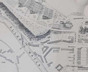
James Steuart had as his 4 times Great Grandfather none other than King James II. He lived to the ripe old age of 100, dying in 1700. In his will he wrote –
“…immediately upon my decease to pay out of first and readiest of my goods and gear to the Kirk Session of Logie for ye use of ye Poor, the sum of fifty merks, Scots money.”
Logie Parish Kirk was heavily involved in the area at this time. Records show repeated payments of 6s 8d Scots paid to Walter Towar for the excavation and backfilling of graves for “…poor folk that dyed in the Paroch…”
In the 16th Century the lands of Cornton were farmed by a number of people under a system whereby the ownership was distributed in fractions among “Portioners“
In 1702, one of the portioners of the Carse of Corntoune, who was to become master of Brigend, Archibald Ogilvie, went to Dunblane to be married. There, he was wed to Katherine Chrystiesone. It was a society wedding with, (according to Katherine Steuart) “William Ogilvy in Corntoune, and Harry and James Ogilvys” in attendance. This is something that requires to be clarified because Fergusson in his history of the Parish lists the lineage such that William is Archibald’s son and James and “Harrie” are his grandsons! It is possible, however, that they were all named after others.
It is recorded that “…the Chrystiesones were a very ancient carse family, originally of Danish descent, who had settled in Corntoune at an early date under the lordship of the Monks of Cambuskenneth…”
According to Katherine Steuart, an English soldier, returning late at night from a visit to Stirling “…Inquiring for “one Chrystiesone” found himself driven… from one farmhouse to another till towards daylight he exclaimed in bitterness of Spirit-“this whole cursed country is full of Chrystiesones and not one Christian among them all!”
From these writings one can glean that the lands of Corntoune during the 17th and early 18th Centuries were farmed in lots by portioners who would most likely have worked the land on the Run Rig system.
More of Cornton and it’s Portioners can be discovered here in the chapter thus entitled within Fergusson’s “Logie: a Parish History Vol. 2”.
This would all change during the 18th Century as larger individual holdings became the norm.

Edgar Williams’ map of 1745 makes no mention of either Cornton or Bridge of Allan but continues to reference “Ethra”. It does mention the village of “Pathfoot” which is referred to in Katherine Steuart’s book. The book was published before 1901 and acknowledges, even at that time, that “…Pathfoot has now vanished completely…”
Pathfoot was located in the Airthrey Estate. It was cleared in 1815 and the only remaining evidence is the building known as Blawlowan or East Lodge.
John Berrihill’s painting of the Old Bridge commissioned by the Tolbooth of Stirling is dated 1705 and shows Brig Mill on the south side of the bridge and what is said to be Bridgehaugh farm on the northern side.

Alexander Beith McDonald’s map noted (in pencil in the margin) to be c. 1700 shows very little on the Cornton side of the bridge but does show Bridgehaugh Farm. This map, if correctly dated, confirms the existence of Bridgehaugh at the beginning of the 18th Century. Bridgehaugh Farm did not appear in any other maps until 1780: –

There are two notable references on this map. One at each end of the old Bridge. On the Northern end there is the description “Brig Port”. The word “Port” here would probably refer to “door” or “Gate”. There were, originally, archways at each end of the bridge and the one to the north-east end had an iron gate which was replaced by small square pillars with pyramidal finials, still extant . And then on the southern end there is noted to be a Guard House. These both show on the Berrihill painting.
There were a few map makers of this era who recorded Cornton with different results. William Edgar’s map of 1746 (left) shows a simple icon of a farmhouse beneath the word Cornton. There is every possibility that the farmhouse identifies the steading that is Wester Cornton Farm, known to have been in existence in 1706. The map of Charles Ross in 1780 (right) in the same vicinity, shows an indication of a property called Netherton. It’s the only time that the name shows up in those times, but there is a development on the Carse of Lecropt Road North of the Allan Water (In the vicinity of the “Bleachfield”) currently called Netherton which appears to be a development of a historical farmstead. There are other maps of the time that show Netherton on the northern side of the Allan Water.


The inaccuracies and differences between the individual Mapmakers was to change dramatically with the establishment of the Ordnance Survey. This Government Organisation regularly updated its data as development of all areas proceeded through the Industrial Revolution.
Suffice to say that the area was populated by a farming culture and at this time a huge change was taking place in farming practices across the country as a result of innovation in ploughing technology; the “New Husbandry” as it was known by Carse folk. In 1751 Mr Drummond of Blair sent his ploughman to Ayrshire “…to learn drill husbandry and the culture of turnips from Lord Eglinton’s English servants…” “…A single horse ploughing the drills astonished the people who had never seen fewer than four yoked…”
The Rotherham plough” was to revolutionise farming practices right up until the advent of the tractor. The success of the physical side of farming in that manner was further enhanced by the introduction of the addition of Lime to the soil. “… the limestones were landed about Causewayhead and carted in dry weather through the lands of Corntoune…”
“1782 was long remembered for its Frightful weather…” says Katherine Steuart “…And yet, even in this wretched season, John Steuart’s usual good luck did not forsake him…” “By the end of October the stackyards of the Corntoune Carse were filled to overflowing, and the portioners of that favoured locality reflected with satisfaction that the less food there was in the county the higher would be the price fetched by their own produce…”

The Grassom Map of 1817 shows a far greater population of farms in the area and seems to be a far more accurate representation of the geography of the area. Wester Cornton, Cornton, and Easter Cornton Farms are all depicted along with West Haugh and, although not named, also Bridgehaugh.
These things should be considered in the light of the fact that, at or about the same time, fifteen thousand people were cleared from the estates of the Duke and Duchess of Sutherland to make way for sheep.
In that map there are many references to Corntown and for the first time “Bridge of Allan appears as an entity.
Between 1815 and 1846 the “Corn Laws” restricted the import of food from overseas. “Corn” in that respect included all cereal grains such as wheat, oats and barley. The laws were designed to keep corn prices high to favour domestic farmers by blocking the import of cheap corn.
However these laws enhanced the profits and political power of land owners and did nothing for the lower classes, those who were working the farms, by raising food prices and the cost of living.
According to one 2021 study, the repeal of the Corn Laws benefitted the bottom 90% of income earners in the United Kingdom economically, while causing income losses for the top 10% of income earners.
John Wood’s map of 1820 professes to be “By actual Survey” and shows Bridgehaugh Farm and Bridge House (not the one that exists today) on the northern side of the river: –

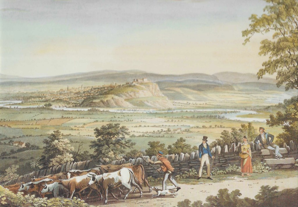
This next painting of Stirling Castle by I. Clarke dated 1820 (published prints by Smith and Elder 1824) shows the Castle of course but also shows the Old Bridge in the context of much of the agricultural Carse of Cornton. If you look carefully you can just make out what could be Wester Cornton Farm above and to the left of the chap in the top hat. Then a wee bit further up, the smallholdings that would eventually become Corntonvale. The foreground shows what looks like some Bridge of Allan locals, or maybe visitors to the Spa, out for a leisurely stroll, encountering a drover as he takes his cattle to market along one of the historic drove roads likely the Pendreich road.
In the bottom left of the picture there is a small group of houses. This could be Blawlowan which is all that remains of Pathfoot village which was a centre for shoemaking and a Cattle market. The village was cleared in around 1815.
John Thompson’s Atlas of Scotland 1832 shows the area as follows, including the title “Corntown” and again shows Bridge of Allan: –

A study by Rathmell Archaeology Ltd., which was carried out on behalf of the Scottish Prison Service in 2017 in advance of the redevelopment of the prison site, takes the following view of the content of this map: –
“Our Cornton, in the early 19th century (Grassom 1817), appears to comprise a string of structures along the north side of a minor road. At the western end is a distinct courtyard farm with further four structures running eastwards. A line of trees borders the north side of all the structures and suggests that, possibly, each had their own small holding.”

Much of the report of Rathmell Archaeology Ltd. seems to be based upon the belief that Cornton was a localised entity comprising a small village or group of smallholdings.
The area, that previously housed the smallholdings, was on a road that led from the Cornton Road from Causewayhead up to Lecropt via a ford in the Allan Water. The remnants of that road are still apparent and run behind the new Prison fence.: –
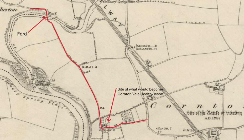
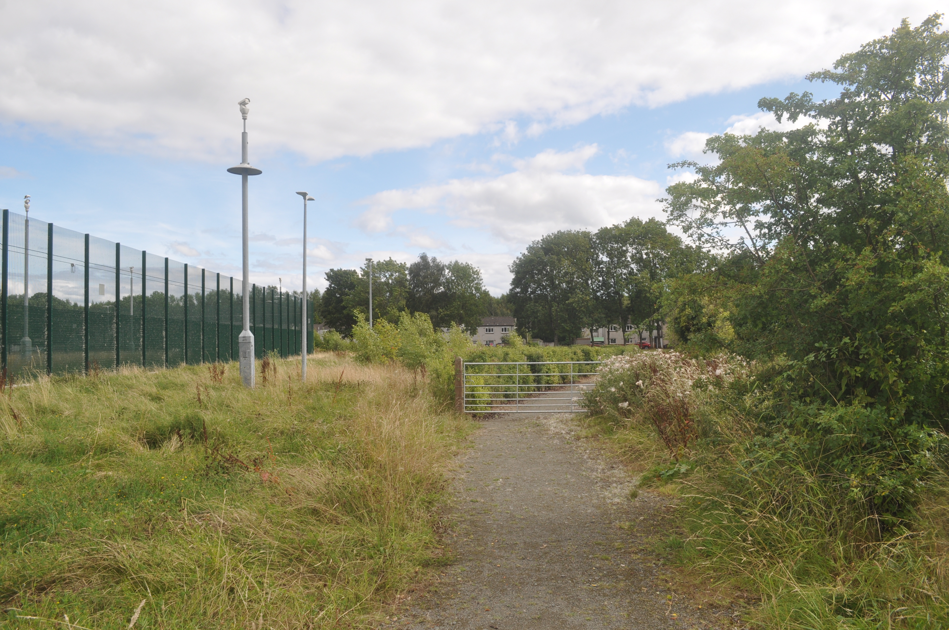
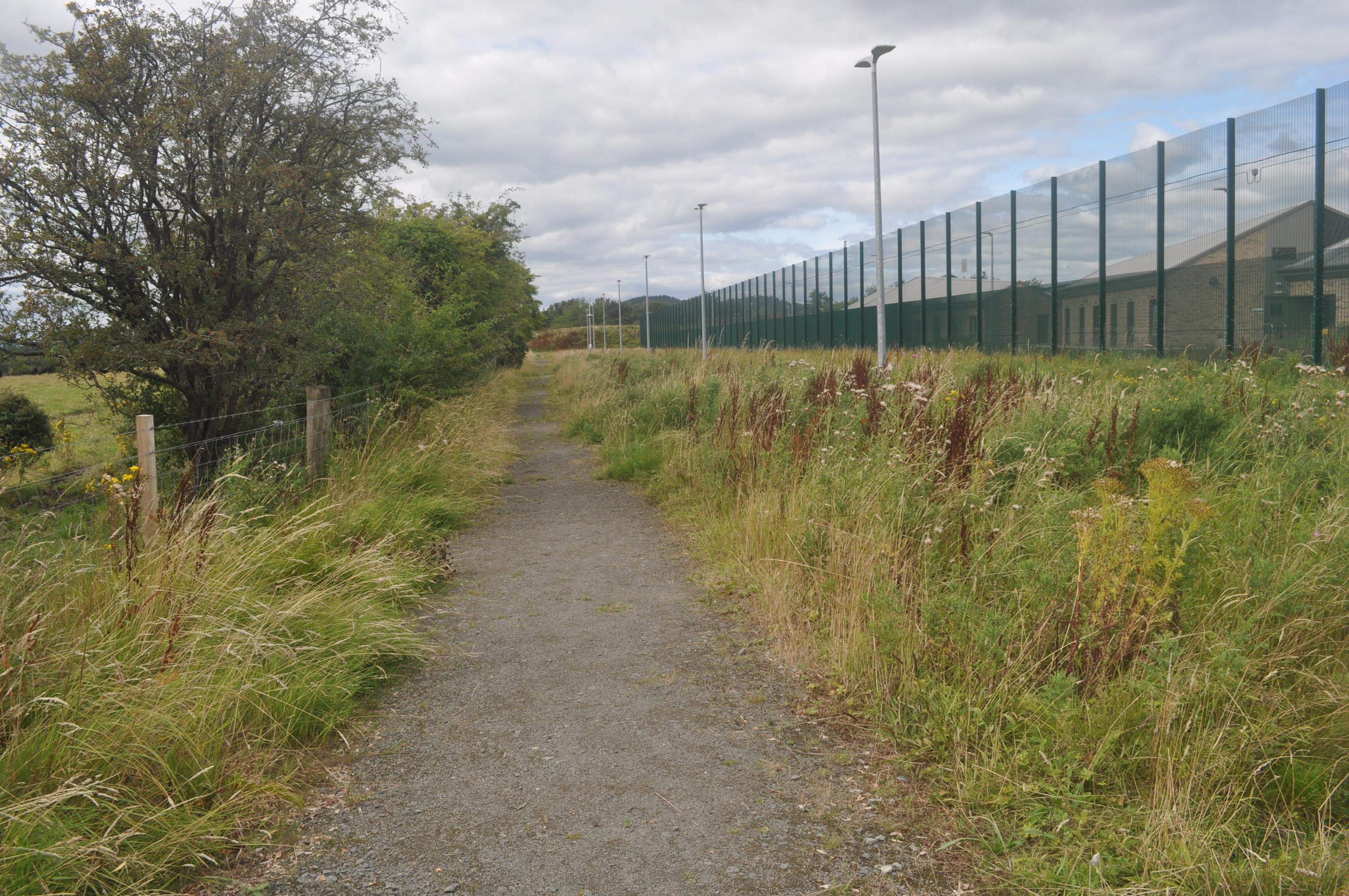
Looking South back to Cornton (Castle) Vale And looking North towards Lecropt.
That 1861 Ordnance Survey map shows how the railway has scythed through the lands of Wester Cornton Farm. It also shows the group of buildings that is referred to by Rathmell Archaeology Ltd. as what comprises “…our Cornton…” in much more detail. This area would be consumed by the development, in 1871, by John Thomson, a farmer from Drumtogle near Auchterarder. He built a new farmhouse and steading on the site. It was he who christened the site which has been known as Cornton Vale ever since. Initially he advertised the site as “Cornton Vale House Health Resort”.
The original Cornton Vale was developed as “Castle Vale” when the Women’s Prison was built further north in 1975.
The new facility, built in the early 2020s, eschewed the continued use of the title and renamed it “HMP & YOI Stirling”. There is now nothing in the area that will carry on the name “Cornton Vale”
Before the railway cut it into two distinct areas in 1848, Cornton would have occupied almost everything between the river on the South and West up to Airthrey. But, with the railway heading North and West to Perth via Bridge of Allan, a burgeoning Spa Town at that time, Cornton was reduced by more than half and Bridge of Allan and Causewayhead occupied the remainder.

For the purposes of this Website “Cornton” is described as the area enclosed by the River Forth to the West and the Railway line to the East. “Cornton” or “Corntown” or “Corntoun”, as described above, at one time covered a much larger area before the railway cut through leaving our Cornton on one side and Causewayhead and Bridge of Allan on the other. Some names, however, have remained. Easter Cornton road and Cornton Farm buildings with the Monument Dance Centre are still there while The Birds and Bees occupy what was once Easter Cornton Farm.
We have catalogued as much information as we have, relating to what might be described as “Modern History”, into the various categories highlighted in the index on the home page and thereafter along the navigation bar at the top of each page. Feel free to browse by clicking on the topic of your choice.