In the Mediaeval period the produce of the lands of Cornton was providing sustenance for the Monks of Dunfermline and the Nuns of North Berwick. This was a tradition that required the “Teinds” (a tenth of the value of the produce) of the land to be paid to those sorts of institution for the support of religion. Who actually owned the land, if anyone, is a matter of conjecture. Later it becomes apparent that the Crown is the establishment that controls the land.
Craig Mair recounts in his History of Bridge of Allan that, in the early 14th Century the lands of Cornton which “…lay between Airthrey and the River Forth, and stretched from the mouth of the Allan Water to Stirling Bridge…appear to have been Crown property and seem to have been a separate barony or estate.”
From Logie A Parish History (The portioners of Corntoun): –
In the mid 1500s all the Corntoun charters reserve to the King (or Queen) the fishings of salmon, the grilses, and smolts, and also the coal and other minerals.
This description seems to reflect the burdens that later apply to pretty well all of the Feu dispositions executed in Scotland right up until the end of the 20th Century although reserving these things for the “Feu Superior” rather than the Crown.
But: –
From the genealogy of the Sinclair family: –
On the 20th of November 1544, Janet Sinclair and her husband were rewarded by the Queen Dowager (Mary of Guise) with a life rent of the mails, profits and duties of the town and lands of Corntoun, with its meadows and fishings in Logie Parish, Stirlingshire for “the service of said Janet as our nurse.”
It is recorded that Stirling Castle was a dowry gift from James V to his Queen, Mary of Guise. She seems to have spent long spells at the castle and clearly came to depend much on the support of those around her. In 1541 she began the process of distributing parts of the Cornton lands to Trusted servants. Janet Sinclair was one of those who benefitted from that. Earlier, in 1494, one portion of the Cornton lands had already been granted to William Erth, the chief Cook at the Castle. There were others too. John Mowat the Queen’s “maister of stable” was one of those who benefitted, being described as “Servitours to the Queen’s grace”. These people in turn would have been able to rent out their allotted portion and maintain an income from it.
And then again from the “portioners of Cornton”: –
1549-50 (20th March). — Charter to John Christison in Cornetoun of a sixth part of the lands of Cornetoun, to be held by the said John and his lawful male heirs of his body, whom failing, his eldest heir female without division.
1578 (5th June). — The testament of John Christie, elder, portioner of Corntoun, who died 31st July, 1577, is made up by James Christie, his son. Helen Cowan was spouse of the deceased.
1593-4 (8th February). — Charter to John Chrystisoun, son and heir of the deceased Stephen Chrystisoun, son and heir of the deceased William Chrystisoun in Corntoun, of a sixteenth part of the town and lands of Cornetoun, of which the said John and his father, and their predecessors were native tenants, and rentallers past the memory of man.
1597-8 (2nd March). — Charter to James Crvstesoun, son and heir of the deceased John C, portioner of Cornetoun, and Margaret Lokhart, his spouse, in liferent, and to Malcolm C, their eldest son, in fee of a sixth part of the lands of Cornetoun.
In her book “By Allan Water” Katherine Steuart tells us that “…the Chrystiesones were a very ancient carse family, originally of Danish descent, who had settled in Corntoune at an early date under the lordship of the Monks of Cambuskenneth…”
Although Janet died in or around 1557 this would lead one to believe that these Charters were granted by Janet Sinclair or her husband (d. 1588). Whether they constituted some sort of sale or whether they were paying rent to her as well as paying Tithes to the Parish is unknown. However again from the “portioners of Cornton”: –
1604 (10th February). — Charter confirming a charter by John Crystesonn, dated 2nd and 8th December, 1597, by which for payment of eighteen hundred merks he, with consent of Helen Drummond, sold to John Drummond of Slipperfield (then designed of Hawthornden), and Susan Fouller, his spouse, a sixteenth part of the town and lands of Cornetoun ; also a charter by the said John Drummond of Slipperfield, dated 22nd July, 1603, selling above lands to John Donaldson, merchant burgess of Stirling, and Mariota or Maus Auchmowty, his spouse.
So, at least at that time, the Christiesons had been owners of a substantial part of Cornton.
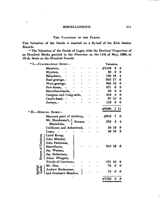
This is the Valuation of the Parish in 1698 as portrayed in a fly leaf of the Kirk Session Records.
“Teinds” is defined as a 10th part of the produce of the land for the support of religion.
It is notable from this that there are no Christiesons mentioned anywhere by 1698.
Among the “Fewers” (archaic of feuars) is John Paterson. On the marriage lintel above a door at Wester Cornton Farm it tells us that I.P. (Ian Paterson?) married M.E. in 1706. Could this be the same man?
Following the Reformation in 1560 many church buildings were destroyed and replaced with new more “Presbyterian” buildings. The Logie Church was not one of those but, for many, it is reported that the teind lands of many were appropriated by the local aristocracy.
In 1633 John Cowane died. A wealthy man, he left sums of money to numerous charitable causes including 500 merks to the Church of the Holy Rude. The largest bequest was the 40,000 Merks which he left for the establishment of a hospital/almshouse to provide for twelve decayed (elderly) guild brethren. One Merk was the equivalent of two thirds of a Scots Pound. The bequest was enormous and equates to millions in today’s money.
Cowane’s Hospital became a unique and incredibly powerful “landowner” in the Carse. It was a wealthy charitable trust managed by the Stirling Town Council and Guildry. The Trust systematically purchased large sections of the Carse of Stirling—specifically around Bridge End, Raploch, Cambuskenneth, Riverside, Spittaltown, and segments of Cornton (1708)—to generate rental income for the city’s poor.
Following completion of Cowane’s Hospital, during the latter part of the 17th and 18th centuries, more areas of land in Stirling were purchased by the Trust. The Raploch area came to the Trust as a result of an unrepaid loan to the Earl of Mar. Up until 1779 it, like Cornton, continued to be farmed in small plots/strips and from 1798 it became one large farm. From the late 18th century, the Trust began to feu land particularly the area which is now the Raploch Road, overtime this developed in to the Raploch village.
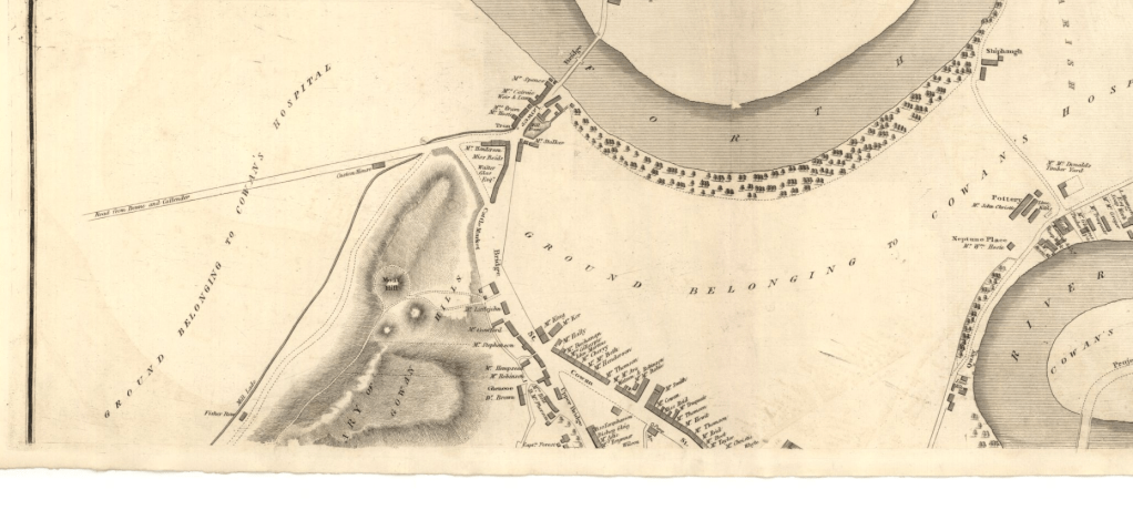
During the 18th and 19th centuries, parts of Cornton and the Bridgehaugh area were purchased by the Cowane’s Trust along with the areas of Riverside (Shiphaugh) and Cambuskenneth to generate rental and agricultural income to fund the Almshouse and charity work.
The Trust actively subdivided and leased these lands (‘feuing’) to expand local industries, farmers, and residential developers as Stirling grew outward from the old castle rock.
The low-lying carse land of Cornton was ideal for the extraction of clay and in the 19th Century, “Cornton Brick and Tile”, headed up by George Christie, acquired the rights to extract clay and build kilns by securing long-term mineral and agricultural leases from Cowane’s Hospital Trust. Because the ground was full of heavy, carse clay, it was agriculturally difficult to manage until George Christie turned it into a massive extraction site. His business model was highly advantageous to the local lords: he extracted the raw clay to make drainage tiles, and the landowners used those exact tiles to drain the rest of their agricultural estates.
Because George Christie eventually became a prominent Stirling Town Councillor, his business dealings were heavily intertwined with this specific Civic Trust.
As the business exploded in scale—with George Christie eventually employing nearly 100 workers by the 1860s—the family used their profits to systematically buy out the titles to their leased lands. This converted their temporary clay-extraction fields into permanent corporate assets.
By the time George Christie died in 1867, these piecemeal leases had successfully been consolidated into a vast, privately owned land portfolio. This was the exact portfolio his son John inherited and eventually divided, selling the 34-acre slice of Cornton to John Thompson in 1871, a farmer from Auchterarder. This was the land, which Thompson would christen Cornton Vale. The sale was part of the restructuring of the Christie family’s extensive property and industrial holdings in Stirling, which John fully inherited after his father George’s death in 1867.
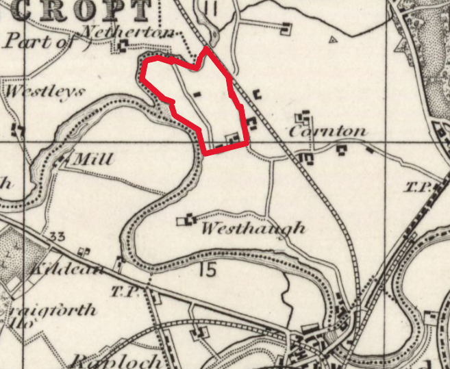
We have no accurate record of where these 34 acres were but coincidentally the area enclosed by the river to the West, the B. of A. road and railway to the East and the old road upon which Cornton Vale stood in the South approximates to just that.
Considering that, at the end of the 19th Century, it is recorded that the land to the north of the Rubber Works is “unfeued” and in the ownership of The Cowane’s Hospital Trust this would not be an unreasonable assumption.
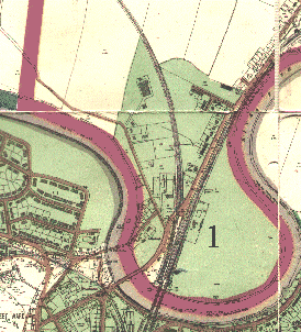
In 1939 The Burgh of Stirling boundaries were altered to include land north of the river including a part of Cornton up to the pedestrian level crossing at Easter Cornton Road but excluding the lands of Westhaugh Farm and beyond. Prior to this date the northern Burgh Boundary was the river. This map of the time also records the vast areas over which Cowane’s Hospital Trust were Feu Superiors coloured in green.
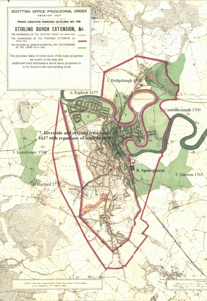
When a closer look is enabled it is seen that in 1939 Cowane’s Trust were Feu Superiors over all of the land of Cornton up to and including McGrouther’s bacon Factory. It would appear, if the Brick and Tile Company had leased any of the land north of that which they subsequently bought, that they also bought out the superiority at the same time.