In 1693 Sibbald wrote the original text for ‘Theatrum Scotiae‘ in Latin, working with Slezer but Slezer had it translated into English without Sibbald’s agreement and published it without acknowledging him.


Historical photographs of the Old Bridge, from the South and then from the North.
The significance of Stirling old Bridge insofar as we are concerned is that, historically, it was the only bridge access from the South of the river, through what we know as Cornton, to the north.
That “Old Bridge”, that we know today, was not the first! The present “Stirling Old Bridge” was built in the 1400s or 1500s, replacing a succession of timber bridges.
On the “Heraldry of the World” Web site in relation to the Arms of the Burgh of Stirling there is a suggestion that there was a previous stone bridge c. 860: –


But modern historical analysis shows that this claim stems from a creative interpretation of the same 13th Century Common Seal of the Burgh of Stirling. There is therefore no foundation for the claim that there existed any earlier stone bridge than the one that survives today.
Matthew Paris’s Map of great Britain c. 1250 shows a bridge (pons) at Stirling although the map is so inaccurate that a fair bit of imagination is required to verify the locus. The tell tales are what must be Dumbarton in the west, Dunfermline and “Fif” to the East, St Andrews and Dundee on the next estuary up and the notion that beyond the bridge was “Scocia Ultramarina”: –
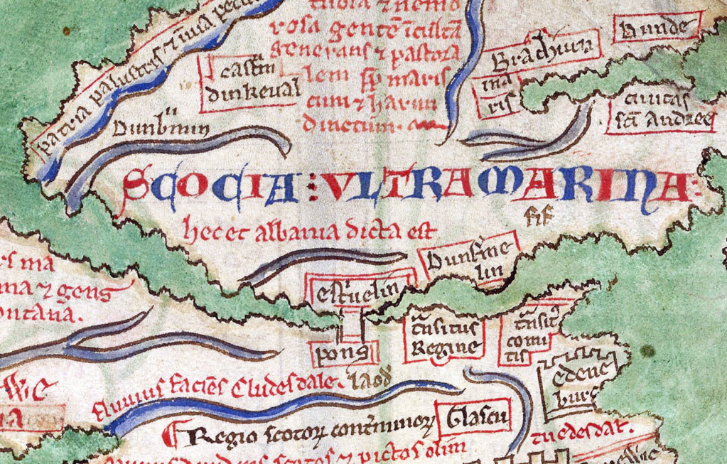
Undoubtedly the best-known of the previous timber bridges was one that stood nearby, when Sir William Wallace and Sir Andrew Moray defeated Edward I’s forces at the Battle of Stirling Bridge in 1297. This could well be the bridge depicted in Matthew Paris’s map.
Record of “Trove Scotland” antiquity No SC 2430899 et seq: –
This is one of the most critical river crossings in Scotland. As “Gateway to the Highlands”, Stirling is of tremendous strategic importance, and the bridge here was the main crossing point of the River Forth until the early 1800s.
The foundations of two piers of a bridge earlier than the 15th century one were discovered in 1905 some 65 yards upstream from the later bridge. The piers were about 28 feet long by 14 feet broad. They were 25 feet apart, the centre of the northeast one being about 25 yards from the Left Bank, and that of the southwest one between 25 and 30 yards from the right bank. These details were confirmed during the drought of 1955.
The word pons appears on three mid 15th century maps and a bridge is represented on the Common seal of the burgh of Stirling in 1296, one year earlier than Wallace’s battle in which the breaking down of the bridge is traditionally an episode.

The tradition implies that the bridge was wooden. and the representation of a stone bridge on the seal is probably a convention. In 1304 an allusion to boats suggests no bridge was available. In 1305 a bridge presumably of timber was repaired. Between 1361 and 1391 a ferry replaced the bridge. In 1407 the bridge was said to be very ruinous. The work carried out then was evidently of some importance and payments to the fabric are recorded in 1408 and 1415. This structure may again have been in wood, as the possibility of it being broken is mentioned by an English spy between 1424 and 1437.
No trace of this bridge is visible at normal low tides.
At or about the time that this bridge was built King James V, at only seven years of age, was crowned at the Castle after his father, James IV had been killed at the battle of Flodden.
Also at or about the same time the Great Hall at Stirling Castle was built.
Now Category A-listed for its historical importance, it was on the Old Bridge that John Hamilton (1547-71), Archbishop of St. Andrews, was put to death.

He was executed in his full regalia having been linked to the murders of Henry Stuart, Lord Darnley (1545-67), and James Stuart, 1st Earl of Moray (c. 1531-70).
John Slezer‘s ‘Theatrum Scotiae’ is an important record of Scottish towns, castles and palaces in the 17th century. For most places, it contains some of the earliest views that survive. These historical records are unique insofar as they give us a visual understanding of what the author saw. Most historical records are purely written accounts. Robert Sibbald (1641-1722) was a physician and geographer. He founded what became the Royal Botanic Gardens in Edinburgh, and also the Royal College of Physicians of Edinburgh.
In 1693 Sibbald wrote the original text for ‘Theatrum Scotiae‘ in Latin, working with Slezer but Slezer had it translated into English without Sibbald’s agreement and published it without acknowledging him. Within that text is reference to the old bridge as follows: –
The King’s Park lies at the very Foot of the Castle, and the City stands on the Back of a Hill toward the South. It is enclosed with a Wall, and toward the North, it is bounded with the River Forth, which crossed by a Bridge in that Place.The Bridge is of hewen Stone, and fortified with an Iron-Gate. It consists of four stately Arches, and lies South and North. The Ships at full Tide come up to the Bridge, and the Haven is a little below the same.
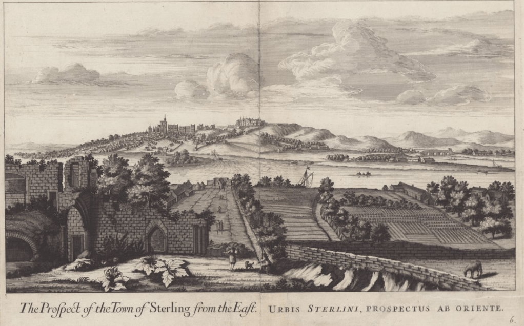
The “Old Bridge” can be seen on the extreme right of the drawing complete with the gate.
In the foreground the ruins of Cambuskenneth Abbey can be seen notably with the absence of the tower that is the only remnant of the Abbey still extant today.
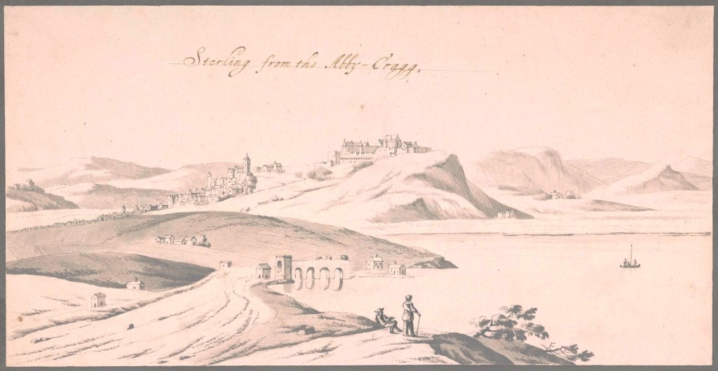
This next drawing by John Slezer shows Stirling and the bridge in the latter part of the 17th Century as seen from the Abbey Craig with a portion of Cornton in the foreground. It is probably unique in showing the Northern gate and guard house in some detail.
In what was a wasted piece of vandalism in 1745 one of the bridge arches was blown up by General Blakeney in order to prevent the Jacobite Highland army entering the town on their way south.

The Army simply forded the river further upstream. It is recorded that Bonny Prince Charlie arrived at Bannockburn House on the 14th September that year.
According to many reports the Bridge was rebuilt 4 years later, however in her book “By Allan Water” Katherine Steuart tells us of something which makes much sense: –
”… a few hours after the blowing up of St Ninians Church, the news was received in the Carse with great thankfulness that the army of Charles was fording the river at Frew and with all speed retreating to the north…”
“…His Majesty’s Army were busy, night and day, repairing Stirling Brig for the passage of the King’s Army…”
“It was a wonderful day at Brigend, that house which lay so well in the line of Scotland’s history, when after the bridge was restored, the King’s Army came slowly over Corntoun, preceded by the Argyllshire Highlanders and a body of Dragoons. Then came more foot soldiers, and then the round-faced Duke of Cumberland, who was hailed as a deliverer by the whole district, so lately harried by the Highlanders”
The website of “geograph.org.uk says that “whilst it had wooden beams across the breach in 1746 it was not repaired until 1749.” Those wooden beams would have been those laid down by the pursuing English army as a temporary expedient. The permanent alterations and repairs to the bridge were undertaken after those hurried repairs. They included the renewal of parapets and the truncation of the pedestrian refuges which formerly had roofs and crow stepped gables. There were, originally, archways at each end of the bridge and the one to the north-east end had an iron gate which was replaced by small square pillars with pyramidal finials, still extant . Sentry boxes can be seen in Slezer’s painting of 1731: –

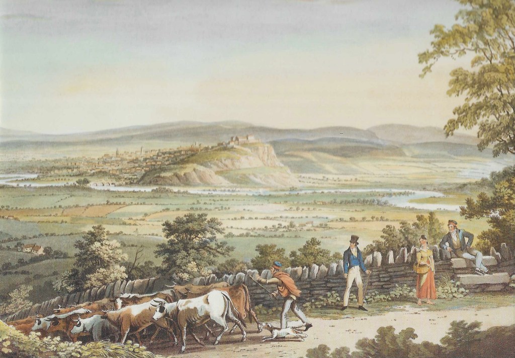
This next painting of Stirling Castle by I. Clarke dated 1820 (published prints by Smith and Elder 1824) shows the Castle of course but also shows the Old Bridge in the context of much of the agricultural Carse of Cornton. If you look carefully you can just make out what could be Wester Cornton Farm above and to the left of the chap in the top hat. Then a wee bit further up, the smallholdings that would eventually become Corntonvale. The foreground shows what looks like some Bridge of Allan locals, or maybe visitors to the Spa, out for a leisurely stroll, encountering a drover as he takes his cattle to market along one of the historic drove roads, likely the Pendreich road. Bottom left there is a building which is quite likely to be Blawlowan, all that remains of Pathfoot Village which was cleared around 1815.
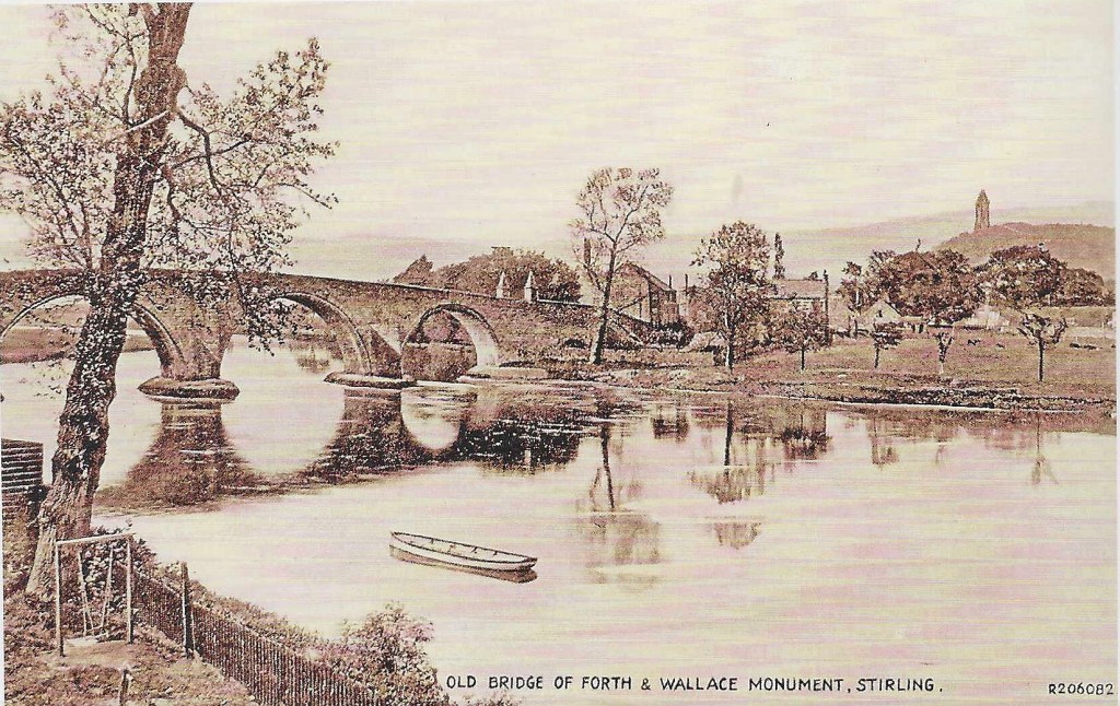
This tourist postcard has no date but shows Bridgehaugh Farm beyond the bridge and the chimney of the Forthvale Mill beyond. This makes it likely to be late 19th or, more probably early 20th century.
The old medieval bridge closed to traffic in 1831 to become a pedestrian pathway and tourist attraction having been replaced by Stevenson’s bridge built in 1829 some 100m downstream.