Bridgehaugh can justifiably be identified as the cradle of the development of modern Cornton. The development of the area known as Bridgehaugh began in the early 18th Century.
Alexander Beith McDonald’s map noted (in pencil in the margin) to be c. 1700 shows very little on the Cornton side of the bridge but does show “Bridgehaugh”.
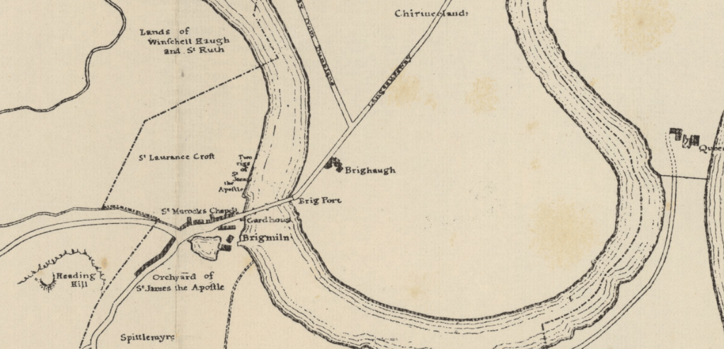

This map of 1725 shows two settlements of some sort, one on either side of the road north from the old bridge. There appears to be two buildings on each area and an indication of some agricultural activity. The road is entitled “Cause Way and Road to Dumblin”. The development is not identified by name in any way.
Also apparent in this map although not on this side of the river is the Mill Dam for what was known as Brig Mill on the south side. The 1859 O.S. Map labels this mill as a Flour Mill. The lade that terminates here at the dam arrives from the Dumbarton Road, north of Cambusbarron, along Back o’ hill.
The 1740 map is little different from the 1725 but does show positive agricultural activity on the north side of the river with indications of field boundaries and tilled or worked ground. The Mill dam is also still evident.

“Bridgehaugh Farm” did not appear in any other maps until 1780: –

Sometime between 1740 and this next map of 1780, Bridgehaugh Farm is firmly established and gives the place its name – “Bridge” from it’s proximity to the old bridge and “Haugh” for the “low lying land next to the river.” The “Bridge House” that is identified no longer exists and would have fallen prey to the development of that area when Cowane’s Hospital sold the area to Robert Smith and Thomas Graham in the mid 19th Century.
Grassom’s map of 1817 shows little change and, although less detailed, it is evident that there are multiple buildings on the West side of the road: –


The Ordnance Survey map of 1861 shows a massive change in the development of Bridgehaugh. Forthvale Cottage appears on Cornton Road and Forth Mill is firmly established across the road from the farmsteading. The railway has been driven through and has isolated the steading from its farmlands. There is a tunnel under the railway to compensate.
The farm was tenanted and leased from Cowane’s Hospital.
On this map at the end of Cornton Road there is the the designation “Cornton TP” with the word “Check” underneath. It is understood that the letters “TP” identify a Turnpike. The word “Check” would imply that this was the point at which tolls for the turnpike road were collected. There is depicted a small building adjacent which one presumes is the office of the Toll Collector. The road was certainly existing as a “Turnpike” in 1837 because it is described as such in the original sale, of that date, of the ground on the west side of the Bridgehaugh Road to Robert Smith and Thomas Graham by Cowane’s Hospital. It was this pair of entrepreneurs that began developing the area that we know as Bridgehaugh.
Although there had been some early toll roads (turnpikes) in Scotland, it was not until the mid-1700’s and later that these became firmly established as a means of improving the road system, particularly when advances in agriculture and industry made the need for good roads apparent. Counties could apply for an Act of Parliament allowing them to raise funds through the collection of tolls and thereby recoup the cost of the construction and maintenance of the road.

As can be seen from this map dated 1900, “Bridgehaugh” is characterised by buildings to the West of the road travelling north from the Old Bridge and the historical farmsteading on the East side.
The buildings on the West side consist of “Bridge House” (Currently known as “Bridgehaugh Cottage”) followed by one block of Flats (No 3 Bridgehaugh) and then the building that was a Cabinetmakers Works in the late 19th Century and later a Confectionery in the early 20th Century. At the northern end of the street is Forth Mills. Forth Mills, existed at the same time as Forthvale Mills across the road. Both were Woollen Mills.
These constitute the cumulative result of the developments brought about by Robert Smith and Thomas Graham beginning in 1837.
Sadly, the poor relative of this area, the block of six flats known as 3 Bridgehaugh, gets no mention anywhere: –

The 1895 Valuation Roll lists a “Manufactory” at the Old Bridge Stirling as being owned by Archibald Forrest and William Forrest, Cabinetmakers, Stirling. The listing continues with six individual records of “House, Forth Bridge, Stirling” all in the ownership of Archibald and William. It is not difficult to leap to the conclusion that these are the six flats at number 3 Bridgehaugh although they are not identified as such. They are however occupied by: –
- Henry Hogg, Millworker.
- William Burden, (No Occupation).
- Archibald Forrest, cabinetmaker.
- James Sneddon, wool sorter.
- James Ogilvie, engine keeper.
- John McFarlane, warehouseman.
The building, to the south of the Mill Building, which had historically been active as a Cabinet Maker’s Factory, owned by Ex Provost Archibald Forrest later became a Confectionery Works occupied by Messrs Leslie. In 1911 the building was completely destroyed by fire. Mercifully no one was injured and the properties on either side suffered only water damage.
A block of flats, designed by John Allan, was built upon the resultant vacant site, sandwiched between the Mill building and the other block of 6 Flats which were confusingly referred to in the 1921 Census as Bridgehaugh! The new flats were to be known as “Brighae” as witness the sign above the door.


The 1940 Valuation Roll lists a “Factory” at “Bridgehaugh Road” owned by the trustees of Isobel C. Lamb, 4 Major’s Place Falkirk and tenanted by “Stirling Ice Company”. There is no indication of which particular building in Bridgehaugh this was, although the only commercial buildings in Bridgehaugh at that time were the Mill building and Bridgehaugh Farm itself.
This photograph shows the last days of Forth Mills with the residential flats that succeeded the Confectionery behind it. You can also see the vestiges of the old Confectionery building in the protruding gable at the southern end of the Mill roof.

In the 1951 Valuation Roll the tenants and occupiers of the Mill Building are recorded as “Scottish Central Poultry Products” along with “Glasgow and West Scotland Aerated Water manufacturers” and the “Beer Bottlers’ Defence Association”!
According to anecdotal evidence, which is quite widely spread, the building was in use as an Egg Packing Plant and an Engineering workshop in its final years and was the subject of a catastrophic fire in the 1970s before demolition. Corroboration of the Engineering workshop can be seen in the sign on the gable which advertises “C. & H. MOTORS” along with a “Castrol” Oil sign on the front facade.
Doug Marshall tells us that the manager of the egg packing plant was a Mr Peter Douglas and the business was closed in the late 1960s. The building was then taken over by Messrs Les Buck and Brian Dormer who traded as motor engineers. In the late 1970s that function was in turn taken over by Charlie Hunter, coincidental with the initials on the sign!

This Clinic building, which was once situated in the area in front of Brighae, was built in the late 40s as a “Child Welfare Centre”. It is typical of many that were built throughout the Country at that time which were instrumental in the inoculation of children against Diphtheria, Rubella, Measles and Mumps among others. An article in the Daily Express of 1942 indicates that 756,022 children were immunised in Scotland against diphtheria in 1941 (and only one of them died of the disease!). At that time 66.4% of Scotland’s 1,155,498 children had received protection from diphtheria. The aim was to reach 85%.

Doug Marshall also reminds us that this was the place where babies were weighed and checked over and the families issued with tins of dried milk. Children under one, and later two, years old were entitled to National Dried Milk, a full-cream product much nearer the real thing than household milk. This was immediately post WW2 and a points system gave shoppers a choice of other foods such as breakfast cereals, biscuits, canned fruit and fish.
This excerpt from Hansard, the official archive of the British Parliament was recorded in answer to a question from Rear Admiral Beamish put to Mr Robert (Baron) Boothby Parliamentary Secretary to the Ministry of Food. Rear Admiral Beamish was worried about the manufacturers of instant food going out of business: –
National dried milk will be available only to infants not more than 12 months old for whom a doctor certifies that dried milk is necessary, and it will be issued only in lieu of the one pint of liquid milk per day to which they would otherwise be entitled under the national milk scheme. Proprietary infant foods, I am informed, are sold to a very much wider section of the population. National dried milk will be issued either free or at 1s. 2d. per packet containing a quantity equal to seven pints of liquid milk. These terms are equivalent to the terms (i.e., free or at 2d. per pint according to the means of the parents) on which liquid milk would be supplied were the child able to consume liquid milk. The price to be paid to manufacturers for national dried milk is at present under negotiation, but I cannot hold out any hope of a subsidy on proprietary foods.
We are told that the doctor in the Clinic at that time had only one arm.
Later in 1970 the building was repurposed as a recording studio which, Colin Roberts reminds us via Facebook, was called “Random Rhythms”. This photograph shows the building just before it was demolished in the early 2020s


Bridgehaugh Cottage, Bridgehaugh Flats and Brighae with Forth Mill Building at the end and Forthvale Mills in the background. The buildings on the left of the picture behind the flats are presumably the “stores” which survived the 1911 conflagration, of the “Stores and Confectionery Works” referred to in the titles. Judging by the vehicles in the picture this is likely to have been taken sometime in the 50s.
On the 1950 Ordnance Survey map the area of ground to the south of the Rubber Works is labelled “Allotment Gardens” but almost no one has any recollection of their existence. Sheena Dorrington-Lonergan, however, says: –
“I used to cycle daily to Riverside Primary School past these allotments at the corner of Cornton Road and Causewayhead Road. I always thought that they were gardens…”

Today, just opposite the flats at 3 Bridgehaugh are a pair of stone pillars taking the form of gateposts. The coping stones of these pillars are adorned with the inscribed names of native Flora and topped with a pair of Basilisks. These were commissioned by the Burgh of Stirling of the sculptress Gillian Forbes in 1990s as part of an environmental enhancement project for the Bridgehaugh Conservation Area. More of the Sculptor’s work can be seen throughout Stirling in the carved writings on pavings recording the history of Stirling.


At the other, northern, end of the same wall there is a terminal pillar which boasts a plain pyramidal coping stone but with more inscribed names of native Flora. All in all there are inscribed on three sides of each of the three coping stones the following: –
- Wallace
- Stone
- Alder
- Ash
- Birch
- Oak
- Pine
- Rowan
- Willow


It is worth having a walk along the park side of that wall where there are embedded a number of slate plaques carved with representations of native flora.