The Street names of Cornton and what they mean
Street names have, historically, mainly consisted of two parts. The first part would give the place a name and the second would describe the type of street. Obviously, recently, this has not always been specifically adhered to, but, for instance, Bridgehaugh, which originally was the name of the farm at that location, gives it’s name to Bridgehaugh Road. Hence the road through Bridgehaugh.
There is a hierarchy of types of Street with “Road” at the top. A “Road” was/is a thoroughfare which led from one place to another. Collins dictionary describes a road as – “A road is a long piece of hard ground which is built between two places so that people can drive or ride easily from one place to the other.”
A “Street” is seen as something which is more likely to be within a locality but is still basically a thoroughfare. This time Collins says “A street is a road in a city, town, or village, usually with houses along it.”
Places like “Wynd” (narrow street) “Lane” (narrow road in the country) and “Avenue” (a wide street with trees on either side) have historically been specific but have become titles given to places in such a manner that they impart a rural idyll to an otherwise less exciting location.
These days Street names are likely to be originated by the developer but approved and coordinated by the Local Authority Street Naming and Numbering section. In both cases more attention is likely to be paid to the name and little to the description. Unfortunately Stirling Street Naming and Numbering Section was unable to help us in identifying the origins of the Cornton Street names.
There has been a convention in Scotland for newly developed areas to reflect the name of a Local, Councillor, Provost or Dignitary and there are a few names in Cornton that might just reflect that convention, but of which we are ignorant. They are marked with a “?”.
We have included a poem at the conclusion of this that was written to make fun of that convention – “The Cooncillor’s Pride”.
Bridgehaugh Road Historical – The flat arable land next to the Bridge.
Haugh Road Scots – Flat arable land next to a river.
(Note that Haugh Rd. is not a thoroughfare but a Cul de Sac. (Literal French translation – Bottom of the Bag)
Bracken Lane These three probably reference the historic rural nature of the area.
The Meadows
Fernbank
Johnston Avenue ?
Cruachan Avenue Ben Cruachan and associated reservoir & Hydro scheme Argyll
Adamson Place ?
Etive Place Loch/ Glen Etive Argyll
Cornton Road Historical Corn Toun referencing the area’s agricultural history.
Strathmore Drive Gaelic Strath is flat arable land and More is a form of the Gaelic Mhor – Big
Strathmore Crescent It might reference any number of places in Scotland with the same name, or else it is a specific reference to the lands of Cornton.
Vorlich Place Ben Vorlich; – Mountains – one above Callander, one NW of Loch Lomond.
Ruskie Road Small Village near lake of Menteith
Menteith Road Lake of Menteith
Achray Drive Loch Achray in the Trossachs, west of Callander.
Easter Cornton Road The road to the old Eastern part of Cornton now Causewayhead.
Lomond Crescent Loch/ Ben Lomond
Westwood Crescent ?
Porter Avenue Probably from the Rubber Works! Maybe historically Porter’s Bar. Located at 63 Port Street, Porter’s Bar was a traditional local pub that originated around 1860 as “The Travellers Rest”. In 1902, landlord William Porter took over and the establishment was renamed Porter’s Bar. It was operated by the Porter family for decades until the last licensee, his son William Dodds Porter, died in 1940.
Smillie Terrace Facebook response suggests a family of Wealthy local Landowners.
Edzell Drive Small Village NW of Montrose
Montgomery Way Likely Field Marshall Montgomery WWII
Castle Vale References the Castle and Cornton Vale.
Forth Park Simply a reference to the River
Vale Grove Probably a reference to Cornton Vale.
Westhaugh Road The western haugh – Westernmost Flat land next to the river
Ferry Court Ferries are recorded where the oldest of the Bridge Crossings were.
Waterfront Way Probably referencing proximity to the river
Fisherman’s Walk Similar, specifically likely the salmon fishing.
Borrows gate Literally translates to “The road to the town’s/burgh’s meadow.”
Fleurs Park Mediaeval; an area of agricultural Cornton also known as “Floors”
Harvest Street Might be a simple nod to the area’s agricultural History.
John Cowane Row Stirling’s most generous benefactor c. 1570
De Moray Court Probably Andrew De Moray, a contemporary of William Wallace
Ben Lomond Drive Ben Lomond Mountain in Argyll
Old Bridge Wynd A Narrow Street or Alley Next to the Old Bridge
Sunnyside Place ?
River Wynd Narrow Street or Alley next to the River.
These explanations are either self evident, confirmed by history or have been extrapolated to take account of geography or language. The question marks appear to be named after some local dignitary but we know not whom. If you know then tell us.
COONCILLORS’ PRIDE
(On the naming of new Streets)
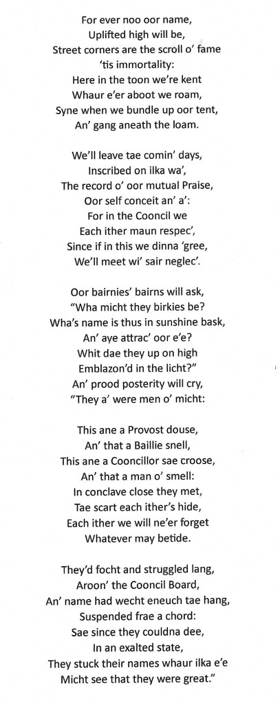
This work is signed only “N.S.H” Credit to the author is implied.

